Just jumping into this again, going to ignore
what I wrote before...
this is art damn it!
So I played around with some ideas for tables, which quickly became more complicated and wonky than I wanted. Rolling at least once, and in some schemes up to three times per 19 sub hexes and the 12 shared hexes... Tedious, but the goal here is fast, easy, and fun if at all possible.
So what is fun? Dice-Drop tables are fun. Well, I can't really use a pure dice drop table, the hexes are where they are. I could use a "Drop and Arrange" table though:
≤3 Primary Terrain (current major hex)
4 Intermediate Terrain 1 (current to nearest)
5 Intermediate Terrain 2 (current to nearest)
≥6 Secondary Terrain (nearest adjacent major hex)
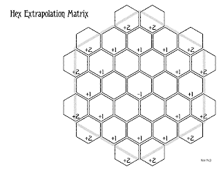
Drop 31d6 and redistribute as needed to fill all available hexes. Dice may be moved either to the nearest empty hex, or arranged to group results into more aesthetic configurations.
Center sub-hex is -1 or 2 die value, next ring of sub-hexes is 0 or -1 die value, next ring is 0 or +1, and shared sub-hexes will be +1 or +2. I will need to play with this to see what modifiers and results I prefer.
I haven't decided how to squeeze in a Special Terrains. I may bake those into the reference tables that will be used to determine which terrains are intermediate. In a water-to-water area, maybe the intermediate 1 or 2 will kick off to a sub table that has a thin chance of producing islands, shoals, reefs, or sargassum.
A box of 36d6 from Chessex is perfect for this, and as luck would have it, the wife got me one a while back, so I am set for the testing phase of this.
I have a rough drop table I am going to dress up and hopefully, the next time I post on this, I will have that along with whatever refinements that testing it out yield.
Regarding Terrain and Biomes:
At this point, I am treating Terrains (geology) and Biomes (environment) as separate elements that coincide on the map. This goes back to an old preference of mine to use color-fill to indicate biomes and symbols to indicate terrain. Many biomes are present on multiple types of terrain. Wetlands and deserts present some special challenges for categorization, but short of going all
science on this, this is a good solution.
Terrains:
Water: oceans, seas, and lakes.
Wetland: semi-inundated land.
Plain: flat, rolling, eroded, plateau (highland), etc.
Hill: foothills, badlands, low elevation escarpments, mesas, and buttes, etc.
Mountain: peaks, ridges, high elevation escarpments, mesas and buttes, etc.
Biomes: (and major breakdowns by terrain)
Barren: Typically arid regions, possible small grass and scrub up to sporadic shrub or trees.
- Bog: peat wetland with stagnant or acidic water and sporadic small plants (wetland)
- Dunes: arid/desert rolling hills of fine sand with rare vegetation (plain)
- Flats: arid/desert stone or hard-packed ground devoid of plants (plain)
- Broken: jagged, rocky, or eroded land with occasional small or medium plants (plain)
- Tundra: rocky permafrost with sporadic grass and scrub (plain)
- Badlands: as broken but with major elevation changes (hill)
- Desert and high-altitude mountains are also typically barren, rocky, and/or broken.
Grassland: Low to medium height soft plants, may include occasional large plants or trees.
- Scrub Desert: arid with coarse soil and low to medium shrub (plain)
- Fens: spring or stream fed peat, top growth of small flowering plants and grasses (wetland)
- Prairie: mainly low to medium grassland (plain)
- Marsh: wetland with dense tall grasses with occasional shrub patches and trees (wetland)
- Savanna, grassland with shrub patches and occasional trees (plains)
Forests: Trees of various sizes with possible undergrowth.
- Coniferous Forests are mainly evergreen pines
- Deciduous Forests are mainly broadleaf trees that shed leaves in fall/winter
- Rain Forests experience high precipitation and are most common in the tropics
- Swamps are wooded wetlands.
- Forests (excepting swamps) generally extend over plains, hills, and mountains.


